Copenhagen Metro Plan
- Copenhagen Metroplan: Effectiveness and Utility of Using a Map
- How is the Copenhagen metro plan structured?
- Lines and stations
- Connections and transitions
- Copenhagen Metro M1 Line Map
- Copenhagen Metro M2 Line Map
- Copenhagen Metro M3 Line Map
- Copenhagen Metro M4 Line Map
- Benefits of using a map
- Easy navigation
- Time saving
- Reduction of stress
- Conclusion: The Copenhagen Metro Plan and the benefits of using a map
- FAQs
- More information about Copenhagen metro
Copenhagen Metroplan: Effectiveness and Utility of Using a Map
The Copenhagen metro map is an impressive example of modern urban infrastructure that connects different parts of the city and makes it easy for residents to get around. You'll see how the Copenhagen Metro map is structured, how useful it is and why it's so important to use a map when travelling by metro.
How is the Copenhagen metro plan structured?
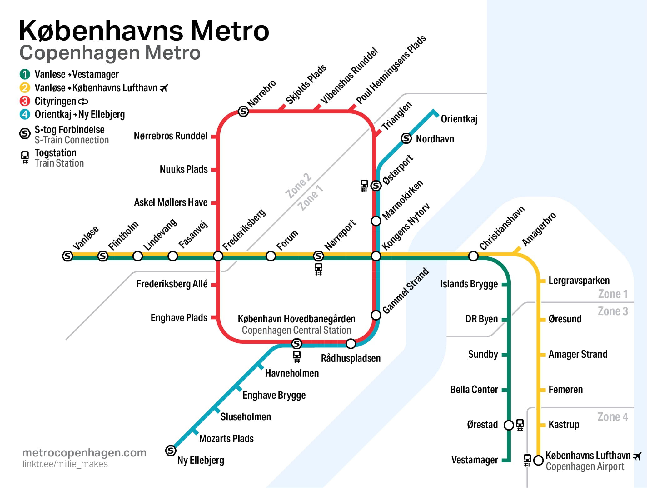
The Copenhagen Metro map is organised in a way that makes it easy for passengers to navigate and find the best route to their destination. The map includes various lines, stations and connections covering large parts of the city and its surrounding area.

Lines and stations
The Metro Plan consists of several lines that connect different parts of Copenhagen and surrounding areas. Each line has a unique colour system, making it easy to identify them on the map. There are also several stations along each line, serving different neighbourhoods and areas.
Connections and transitions
There are several places where the metro connects with other forms of public transport, such as buses, trains and cycle paths. These transitions are clearly marked on the metro map and make it easy for passengers to switch between different transport options.

Copenhagen Metro M1 Line Map
On the Line 1 map you can see all the stations on this metro line in Copenhagen.
Copenhagen Metro M2 Line Map
With the M2 map you will discover all the metro stations on the yellow line of the Copenhagen metro.
Copenhagen Metro M3 Line Map
With this map of the third line of the Copenhagen metro, you can see all the stations that are part of this metro line.
Copenhagen Metro M4 Line Map
Map of the blue line of the Copenhagen metro, with all its stations.
With this map of all the stations on the Copenhagen metro, you can see all the stops.
Benefits of using a map
Using a map when travelling on the Copenhagen Metro is essential to get the best travel experience and avoid confusion or missed opportunities. Here are some of the key benefits of using a map:
A map allows passengers to easily find the nearest metro station, plan their route and identify any transfers or connections to other transport options.
Time saving
By using a map, passengers can avoid wasting time looking for the right route or station. This can be especially useful if you're on a tight schedule or travelling to an important event.
Reduction of stress
By having access to a card, passengers can feel more comfortable and confident when travelling on the metro. This can reduce stress and make the whole travelling experience more pleasant.
Conclusion: The Copenhagen Metro Plan and the benefits of using a map
Copenhagen's metro plan is an important resource for the city's residents and visitors who want to get around in an efficient and convenient way. By using a map, passengers can easily navigate, save time and reduce stress during their travels. That is why it is important to remember to bring a map when traveling by metro in Copenhagen.
For more information about Copenhagen's metro plan and tips for using a map, please visit the metro's official website or app.
The metro copenhagen map is an essential tool for any resident or visitor to the city who wants to get around efficiently and smoothly. This detailed graphical representation allows the different lines and stations to be quickly identified, making it easier to plan routes and optimise travel time.
On the other hand, the metro copenhague plan represents a comprehensive effort to improve and expand the city's underground transport network. This plan includes not only the addition of new lines and stations, but also the optimisation of existing connections, ensuring that all users can enjoy fast, safe and comfortable transport.
FAQs
Yes, the subway offers an interactive map on their website and mobile app that provides real-time updates and directions.
You can download the metro map on your phone by visiting the official metro website or downloading your mobile app from your favorite app store.
No, the use of the card in the metro does not entail any additional cost. It is a free service that is offered for passengers' comfort.
Yes, metro stations often offer free physical cards for travelers to charge with trips and use during their journeys.
Metrokortet opdateres automatisk med nye ruter og stationer, så snart ændringerne træder i kraft. Du behøver ikke at foretage nogen handling for at få de nyeste oplysninger.